Geospatial & Digital Solutions

Geospatial & Digital Solutions

Leading environmental data experts in New Zealand.


Our continued innovation in generating geospatial solutions is backed by our track record of providing engineering and environmental services for more than 30 years.

Our team of specialists use technology to solve problems and present spatial information to aid decision-making for a wide variety of environmental applications. The team provide solutions directly to clients as well as plays a crucial support role for all our workgroups. Developing methods to optimise data accuracy, management and efficiency are important to us and our clients. We place high importance on staying current with technology so that we can offer the most effective solutions.

Services that we provide:

  • Spatial data management and database design
  • Development of web maps, apps and services
  • Mobile GIS applications for field data collection
  • GPS technologies for high-precision data capture
  • Data integration, process automation and ETL
  • Development of tools and workflows
  • Remote sensing, image processing and UAV solutions
  • Machine learning to support the classification of aerial imagery
  • Expertise with a wide range of data formats and standards
  • Integration with CAD and 3D modelling
  • Delivering GIS training and documentation
  • Geospatial analysis

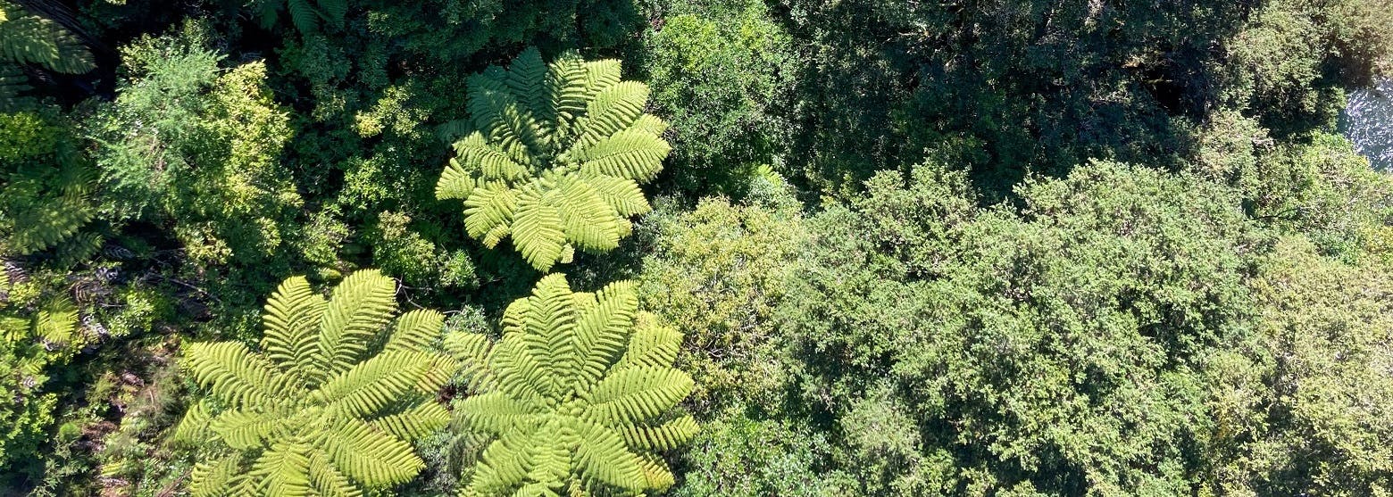
Smarter and more efficient wetland mapping – through the convergence of science and technology

We teamed up with Lynker Analytics to produce the first high-resolution wetland detection map of the Kapiti Coast using machine learning, Light Detection and Ranging (LiDAR) and high res Green-Blue Infrared aerial imagery. Click through for all the details of this project. 

David Klap
David Klap

Technical Director - GDS

Auckland

See Bio
Close
David Klap
David Klap

Technical Director - GDS

Auckland

David is a geospatial professional with 22 years of experience and leads the Geospatial team in our Auckland Office. He is part of the digital engineering leadership group and works with the team to integrate geospatial tools and techniques into our digital engineering services. David‘s main focus is to develop our people and apply our geospatial capability to help solve our client’s problems.

David has spent over twenty years working in the engineering and environmental consulting business. Over this period he has developed experience in collaborating with engineers, scientists and planners across various disciplines to understand project context and to work with them to provide appropriate GIS solutions. He spent 8 years as a Principal working in a GIS team for an Auckland-based firm and before that spent 14 years working in Perth, Western Australia

David Whitty
David Whitty

Strategic Director - Technology & Innovation

Wellington

See Bio
Close
David Whitty
David Whitty

Strategic Director - Technology & Innovation

Wellington

David is an Environmental Engineer with over 30 years of consulting experience in environmental management, contaminated land assessment and remediation, resource consent applications, consent compliance management, and project delivery. 

David’s expertise and experience encompass property pre-purchase and pre-sale environmental and consenting due diligence; environmental approvals and site assessments for infrastructure development; asset management compliance monitoring and environmental auditing; soil, groundwater and air contamination investigation and risk assessment (human health and environmental); risk-based assessment and management of environmental effects; environmental asset inventories; environmental monitoring field work scoping, Safety management, quality control, and coordination; risk-based contamination management option prioritisation and selection; remediation system design and implementation; environmental management support for facility closure and decommissioning; and effective project management including coordinating multi-disciplinary project teams.

David works closely with PDP’s Geospatial and Remote Sensing teams developing environmental data acquisition, analysis and communication solutions for clients to enhance project efficiency, safety and quality.

Anu Sawant
Anu Sawant

Senior Geospatial Analyst

Auckland

See Bio
Close
Anu Sawant
Anu Sawant

Senior Geospatial Analyst

Auckland

Anu has 18 years of experience (including India and New Zealand) and provides GIS support for PDPs in multiple environmental workgroup disciplines.

Anu has a background in the navigation industry, local government, utilities (water, wastewater, stormwater, and Parks), and asset management systems. 

Anu has comprehensive experience in the ESRI suite of products such as ArcGIS Enterprise, ArcGIS Online, Surevy123, Field-Maps, Operation Dashboard, and Web app builder apps and leveraged the capabilities extensively in many projects.

Anu is responsible administrative management of ArcGIS Online and ArcGIS Enterprise as well as the creation of and maintenance of various fit-for-purpose Apps while looking for solutions to improve project and business efficiencies.

Elizabeth Butcher
Elizabeth Butcher

Service Leader - GDS

Christchurch

See Bio
Close
Elizabeth Butcher
Elizabeth Butcher

Service Leader - GDS

Christchurch

Elizabeth is passionate about creating positive change in the natural world. She brings experience spanning consulting, research and government from NZ, the UK and the USA. Elizabeth specialises in the assessment and management of water quality in aquatic and marine ecosystems and combines her environmental knowledge with technical geospatial skills to improve how people understand and engage with data.

Elizabeth’s technical expertise includes water quality analysis, assessment of environmental effects and development of long-term monitoring programmes. She enhances projects by utilising GIS as a tool to harness the power of data. This has led to award-winning Storymaps and developing GIS-based tools for clients and citizen science. Elizabeth's problem-solving ability has proven invaluable during environmental events, including responding to floods and droughts with the UK Environment Agency.

Outside of working at PDP, Elizabeth's commitment to community shines through her volunteer efforts, enhancing geospatial capabilities within emergency management organisations.

MartinaS 700x400
Martina Smith

Geospatial Analyst

Auckland

See Bio
Close
MartinaS 700x400
Martina Smith

Geospatial Analyst

Auckland

Martina’s geospatial industry experience is based on a strong commitment to producing high quality work to serve the community and the environment.

Esri ArcPro, ArcGIS Online and associated Web Apps are the tools that Martina uses daily providing spatial data-derived products and services for use in environmental management, capital works projects, research, and planning, through the provision of static and online maps, and tools for collection, editing, and viewing data. She has experience in spatial analysis of a broad range of natural and built environment data including fire break design in Tasmanian bushland to sea ice concentration in Antarctica, from land use change detection to flood modelling.

Martina is passionate about working towards a mutually beneficial relationship with tāngata whenua.