Background
The National Policy Statement for Freshwater Management requires Regional Councils to identify and map every natural inland wetland in their regions (anything that is ≥0.05 ha), outside of public conservation lands or waters by 2030. The policy statement also provides direction that regional councils should prioritise wetlands at risk of loss of size or special values. Given the risks to wetlands posed by the urban development plans for the Kapiti Coast District, the timing of work on the whaitua catchment committee plan in this district, and the spatial resources available, the Kapiti Coast District was selected to trial the new predictive wetland detection techniques.
Internationally the task of wetland mapping had been described as one of the most difficult landscape features to map. Wetlands are dynamic and often transitional ecosystems; their interface with terrestrial and aquatic ecosystems are challenging to understand. Expert knowledge is normally required for designing and extracting the most efficient information and to discriminate wetland characteristics.
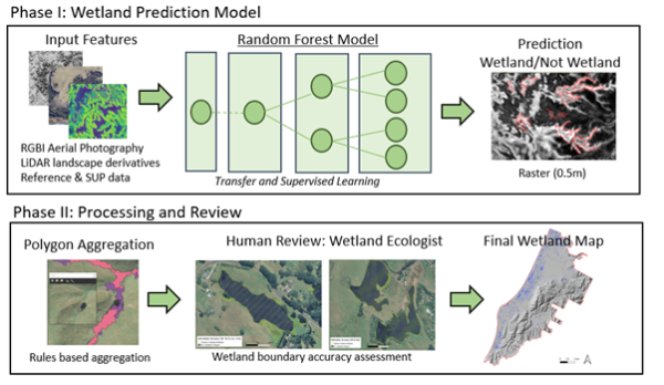
To address this challenge our core team consisted of an integrated team of wetland scientists (including council specialists), remote sensing scientists, data scientists and geospatial specialists all working together to design an approach, train a Kapiti Coast wetland detection model and refine the wetland detection outputs.
Several machine learning models were trialed with a Random Forest decision tree method chosen based on performance and the ability to tune model inputs carefully based on feature importance. Inference cycles were run using Python and Tensorflow/Keras with the mathematical ML models generating predictions using the patterns extracted from the training data sets. Active Learning was used to train the machine learning models; a methodology used to achieve high accuracy models using only the most essential training inputs.
Results
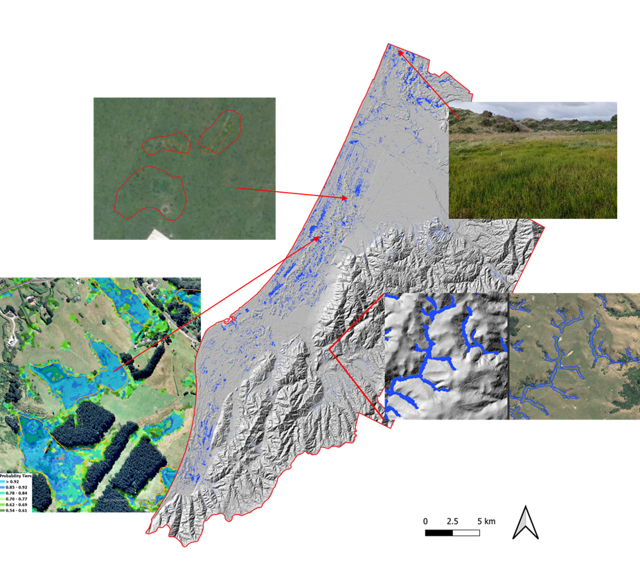
With this approach our team have been able to detect wetlands within the district in a very short time frame (3 months) compared to that needed for conventional methods. This is ideal when time and cost considerations are important and proactive land use decisions need to be made. The results of the assessment are summarised as follows, including some illustrative images.
- Average ML model accuracy was 86%
- Average delineation accuracy of 78.6%
- Detect wetlands of 100 m2 and larger
- Mapped coastal including inland freshwater wetlands
- Detected difficult detectable wetland types
- Derived wetland likelihood tiers
The opportunities
This approach provides a basis for prioritizing wetlands at risk of loss of extent or values. It is a very cost-effective method that can also use freely available regional imagery and training data from other regions may provide a head start and even a cost saving when transfer learning is applied. This approach can be applied region wide and further afield. Additionally, the outputs are a very valuable information source that can guide resource consenting and environmental planning. It provides an understanding of the spatial extent and connectivity of wetlands on a landscape scale and serves as a very valuable resource for the identification of potential wetland restoration areas.